Table of Contents
Units
When the Units switch is clicked, a list of units is displayed. The list contains units that are independently added by the user from the general list of units. The map will display all units of the generated list. The information on the units is updated automatically every 20 seconds.
| Attention! Units are created and edited in the Admin panel. |
To add units, a drop-down list is provided. Add an unit by clicking on its name. To add or remove all units, select Select All or Delete All, respectively.
To search for units quickly, a text field is provided. Search is performed as new characters are entered.
The following elements are located in the line with the name of the unit:
Tracking
When you click the ![]() icon, the map is positioned so that the tracked unit is in its center.
icon, the map is positioned so that the tracked unit is in its center.
Tracking of several units is allowed. In this case, the map is scaled in such a way that all the monitored units are displayed simultaneously.
When tracking is enabled, the icon changes its appearance to ![]() .
.
Information about the unit
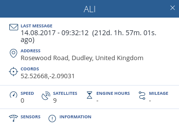
When the cursor rolls over the name of the unit, detailed information about the unit is displayed.
Information about the unit is divided in three blocks:
1. General information showing:
- Last message - Date and time of the last message from the unit;
- Address - Location of the unit at the time of the last message;
- Coordinates - Coordinates of the last location of the unit.
2. Quantitative data block:
- Speed - Speed of the unit in the last message;
- Satellites - Number of satellites with which communication is established;
- Engine hours - Vehicle engine hours;
- Mileage - Vehicle mileage.
3. Additional information Block:
- Sensors – Displaying current information on all sensors created for the unit;
- Information - Additional information on the unit.
Location by LBS
The icon for location verification of the unit under Location-Based Service (LBS) indicates the relevance of the data for the unit and can take on the following form:
| Icon | Meaning |
|---|---|
| The last message was received less than 15 minutes ago | |
| The last message was received less than 60 minutes ago | |
| The last message was received more than 60 minutes ago |
When clicking the icon, the location is determined under Location-Based Service (LBS) system based on the current location of the device.
Track
When clicking, the track of the movement of the unit is displayed for the last 24 hours. The functionality for working with tracking is described in the Tracks subsection.
Status
The status icon serves to indicate the state of the unit and can take the following form:
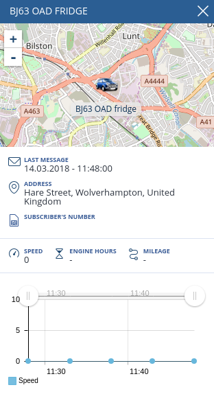
By clicking on the icon, an additional window with detailed information on the unit, including its location, is displayed on the screen.
Simultaneous opening of several additional forms is allowed, which makes it easier to monitor selected units in real time.
The form can be conditionally divided into four blocks.
1. A separate mini-map that allows you to track the movement of an unit with the possibility of zooming.
2. Basic information on the unit.
3. Information obtained with the help of installed sensors.
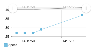
4. Graphical display of information from sensors. By default, the data is displayed for the last five minutes. If the form remains open, the graph is supplemented with incoming data.
Using the sliders, you can scale the graph. In order to hide/display the sensor graph, click on its name. When you move the cursor over the graph, the data at the specified time point for each sensor is displayed.
Options menu
By clicking ![]() you display the Options menu:
you display the Options menu:
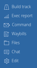
The menu contains the following items:
- Build a track – Creating a track. For detailed description of the function, see the Tracks subsection;
- Run a report – Creating a report. For detailed description of the function, see the Reports and Graphs subsection;
- Command – Sending a command. For detailed description of the function, see the Commands subsection;
- Trip sheet – Creating a trip sheet. For detailed description of the function, see the Trip Sheets subsection;
- Files – View the list of files. For detailed description of the function, see the Files subsection;
- Chat – Chat with the driver. For detailed description of the function, see the Chat subsection;
- Edit – Edit information on the unit. For detailed description of the mode, see the Editing subsection.


